
Discovering God’s World
Why Does the World Look Like This?
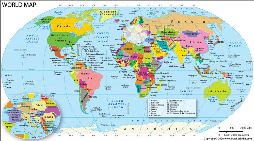
Welcome to your first official geography class!
This year, we are not going to try to memorize hundreds of countries, capitals, and geographic facts.
Instead, we’re going to learn how to picture the world in our minds.
Every time we discover an important place, we’re going to ask three questions:
🗺️ WHERE IS IT?
Find it on a map and figure out how it relates to places you already know.
👀 WHAT IS IT?
What kind of place is it? What makes it interesting or different?
🤔 WHY DOES IT MATTER?
How does this place affect the people, animals, climate, history, or activities there?
By the end of this course, my hope is that when someone says Germany, Japan, the Himalayas, the Amazon, or Egypt, you won’t just recognize the name.
You’ll be able to picture where it is and understand why it matters.
Let’s start by watching this video. As you watch, don’t take notes! Just enjoy it.
When you’re finished, answer one question:
What is one thing you didn’t realize was part of geography?
🌎
This blog has 5 “missions”. Please do all of them. I know its long, but its really just spread out. As you complete this lesson, keep thinking about this question:
How does the physical world influence the way people live?
You are going to investigate six important geographic features:
🏔️ The Himalayas
🏜️ The Sahara Desert
🌊 The Amazon River
🏔️ The Rocky Mountains
🌊 The Pacific Ocean
🌊 The Atlantic Ocean
Learn to find them. Learn what they are. Learn why they matter.
🗺️ MISSION 1
Find It!
Get your world map. You can use your own map at home, an atlas, or an online map. Find the places listed below. In addition to whatever map you use, please print this world map. Or you can print any blank world map that you can mark up. We will be using this for each geography class. Print it, put it in your folder and use it for each class. Don’t throw it away! This is your ticket to class. Here are some links with the map on 2 pages or even bigger on 3 pages. This will make it much easier to label throughout the year.
We’re going to start with six places. I’ve written out the process I want you to use for finding these places on a map.
🏔️ 1. THE HIMALAYAS
WHERE IS IT? Find Asia. Now find India.
The Himalayas are north of India, along the southern edge of the Tibetan Plateau. They include some of the highest mountains on Earth, including Mount Everest.
Find the Himalayas on your map.
Then find:
- India
- Nepal
- China
- Mount Everest
Don’t worry about memorizing all of these. Just get a picture in your mind of where they are.
👀 WHAT IS IT?
The Himalayas are a huge mountain system.
Look at a photograph of the Himalayas or use your map to see how large the mountain region is.
🤔 WHY DOES IT MATTER?
Think about this:
If you lived in a place surrounded by enormous mountains…
- Would transportation be easy or difficult?
- Would farming be easy or difficult?
- Would the elevation affect the climate?
- Where might communities develop?
Write down in your notebook ONE way the Himalayas could affect people who live there. (These are the questions we will answer together in class.) I’ve marked all the questions you should answer in red.
🏜️ 2. THE SAHARA DESERT
🗺️ WHERE IS IT? Find Africa. Now find the northern part of Africa.
The Sahara stretches across much of northern Africa.
Find:
- Africa
- Sahara Desert
- Mediterranean Sea
- Egypt
👀 WHAT IS IT?
The Sahara is a vast desert region.
But here’s something important:
A desert does not have to be hot and sandy.
A desert is defined primarily by how little precipitation it receives.
🤔 WHY DOES IT MATTER?
Imagine living somewhere that receives very little rain.
How might that affect:
- Water?
- Farming?
- Animals?
- Where people build towns?
- Transportation?
Your thought: Write your thoughts down in your notebook.
One challenge of living in the Sahara might be:
One way people could adapt to that challenge:
🌊 3. THE AMAZON RIVER
🗺️ WHERE IS IT? Find South America. Now find Brazil. Find the Amazon River. Follow it toward the Atlantic Ocean.
👀 WHAT IS IT?
The Amazon is a massive river system flowing across South America.
Look at how much land and how many places are connected to the river system.
🤔 WHY DOES IT MATTER?
What could a huge river provide to people?
Think about:
💧 Water
🌱 Agriculture
🐟 Food
🚤 Transportation
🌳 Ecosystems
Choose two and explain why they matter.
🏔️ 4. THE ROCKY MOUNTAINS
🗺️ WHERE IS IT?
This one is close to home!
Find: United States → Utah. Now look north and northeast of Utah. Find the Rocky Mountains.
👀 WHAT IS IT?
The Rockies are a major mountain system of western North America extending through Canada and the United States.
🤔 WHY DOES IT MATTER?
Think about where you live.
How might mountains affect:
- Weather?
- Water?
- Roads?
- Recreation?
- Wildlife?
- Where people build communities?
Tell me why these things matter for where we live.
⭐ Extra challenge
Can you find Colorado?
Can you find Wyoming?
Can you find Montana?
How do these states relate to Utah? (Extra Vanbucks for this question)
🌊 5. THE PACIFIC OCEAN
🗺️ WHERE IS IT? Find the United States. Find the West Coast. Now look west.
That enormous body of water is the Pacific Ocean.
Find:
- United States
- California
- Alaska
- Japan
- Australia
- Pacific Ocean
Now notice something:
Japan is much closer to the United States than it may have seemed before you looked at the map. (This will depend on the map you look at. It might seem like Japan is way on the other side of the world.)
👀 WHAT IS IT?
The Pacific is the enormous ocean between the Americas and Asia/Oceania.
🤔 WHY DOES IT MATTER?
Oceans influence:
- Transportation
- Trade
- Food
- Climate
- Weather
- Where people live
Think:
If there were no oceans, how different would the world be?
Write one thought:
🌊 6. THE ATLANTIC OCEAN
🗺️ WHERE IS IT? Find the United States. Now look east.
Find:
- Atlantic Ocean
- Europe
- Africa
- United Kingdom
- France
- Spain
Now look at the relationship between the United States and Europe.
🤔 THINK
If someone tells you: “My ancestors came from Germany.”
Would you expect Germany to be east or west of the United States?
Now find Germany.
Look at where it is in relation to the Atlantic Ocean.
This is how we’re going to build our mental map:
United States → Atlantic Ocean → Europe → Germany
You don’t have to memorize it.
Picture it.
🧭 MISSION 2
Become a Geography Detective
Now choose one of the six places you just explored.
I chose:
Answer the three questions:
🗺️ WHERE IS IT?
Describe its location using places you already know.
For example:
“The Himalayas are in Asia, north of India.”
My answer:
👀 WHAT IS IT?
What kind of geographic feature is it?
🤔 WHY DOES IT MATTER?
How does it affect people, animals, climate, transportation, agriculture, or something else?
🌎 MISSION 3
Explore Somewhere New
Now choose one country or landmark anywhere in the world that interests you.
It could be:
- Somewhere you’ve visited.
- Somewhere you want to visit.
- Somewhere your family has lived.
- Somewhere you’ve heard about.
- Somewhere you simply know nothing about!
My country or Landmark:
_______________________________
Now find it on your map.
🗺️ WHERE IS IT?
Describe where it is in relation to places you already know.
Don’t simply say:
“It is in Europe.”
Try:
“It is in central Europe, west of Poland and east of France.”
My answer:
👀 WHAT IS IT?
Find one interesting physical feature there. If you are finding a landmark, or physical feature, tell us some other things that are near it.
🤔 WHY DOES IT MATTER?
How might that physical feature affect the people who live there?
🎮 OPTIONAL: TRY TERRAFORMA
If you have time, try National Geographic’s Terraforma interactive.
National Geographic — Terraforma
In this activity, you manipulate terrain and observe how geographic conditions affect climate. National Geographic’s current resource specifically asks students to consider how elevation, deserts, forests, tundra, seasons, wind, rain, and other factors affect temperature and humidity.
After playing, answer: (Vanbucks rewarded for doing this)
What was one thing you changed that affected the climate?
What surprised you?
📖 MISSION 4
See God’s Hand in the Earth
Now we’re going to connect geography with the gospel.
Read:
Doctrine and Covenants 59:16–20
As you read, notice the many things the Lord describes as coming from the earth and being given for our benefit. The passage also teaches that these gifts are to be used “with judgment, not to excess.”
Think about everything you’ve seen in this lesson:
Mountains.
Rivers.
Oceans.
Deserts.
Plants.
Animals.
Water.
Food.
Natural resources.
Answer:
What is one thing about the earth that you feel grateful for?
What does being a good steward of God’s creations mean to you?
🗺️ MISSION 5
Add to Your World Progress Map
Today, add these places to your World Progress Map: (This is the map you printed.) You will have to write very small and very neatly. Make it pretty and colorful.
Continents & Oceans
☐ United States
☐ North America
☐ South America
☐ Asia
☐ Africa
☐ Pacific Ocean
☐ Atlantic Ocean
Geographic Anchors
☐ Himalayas
☐ Sahara Desert
☐ Amazon River
☐ Rocky Mountains
Countries
☐ Canada
☐ Mexico
☐ Brazil
☐ India
☐ China
☐ Japan
☐ United Kingdom
☐ France
☐ Germany
☐ Egypt
Don’t try to memorize all of these.
Your job is simply to find them and begin building a mental picture.
⭐ COME PREPARED TO SHARE
We will discuss what we learned in class and share some of our answers. You should have found 20 + places/things on your map. You should have answered questions for the first 7 things you found.
You have just begun something we’ll continue for the next six months.
We’re not trying to memorize the world.
We’re learning to see it.
Every time we learn about a new place, remember:
🗺️ WHERE IS IT?
👀 WHAT IS IT?
🤔 WHY DOES IT MATTER?
And as we study God’s world, remember that the people who live in every one of these places are His children too.
